![](/images/other/stat-length.png)
![Randonnée Marche Le Coudray-Montceaux - Le sentier de la Seine entre Le Coudray Montceaux et Ablon sur Seine - Photo](https://media.geolcdn.com/t/1900/400/ext.pjpeg?maxdim=2&url=https%3A%2F%2Fservices.sitytrail.com%2FGeolivesWS%2FDownloadMedia.ashx%3FTrailID%3D316711%26Media%3D4359_2.jpg)
Le sentier de la Seine entre Le Coudray Montceaux et Ablon sur Seine
tracegps
Utilisateur
![Longueur](/images/other/stat-length.png)
![Altitude max](https://static1.geolcdn.com/siteimages/upload/files/1508320355ic_sort_altitude_max_24dp.png)
![Dénivelé positif](https://static1.geolcdn.com/siteimages/upload/files/1508320355ic_sort_den_pos_24dp.png)
![Km-Effort](/images/other/stat-length.png)
![Altitude min](https://static1.geolcdn.com/siteimages/upload/files/1508320355ic_sort_altitude_min_24dp.png)
![Dénivelé négatif](https://static1.geolcdn.com/siteimages/upload/files/1508320355ic_sort_den_neg_24dp.png)
![Boucle](https://static1.geolcdn.com/siteimages/upload/files/16400158638029165_repeat_loop_refresh_sync_direction_icon.png)
![Marche](https://static1.geolcdn.com/sitytour/trail-icons/101.png)
6h45
Difficulté : Difficile
![Scannez ce code QR pour ouvrir la randonnée dans l'application SityTrail](https://capi.geolives.com/qq0zvz2zws4bq2lad0pu/sitytour/trails/316711/qr.png?size=200)
Application GPS de randonnée GRATUITE
À propos
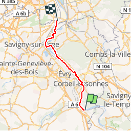
Randonnée Marche de 26 km à découvrir à Île-de-France, Essonne, Le Coudray-Montceaux. Cette randonnée est proposée par tracegps.
Description
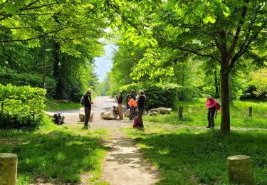
Venant de Bourgogne, le GR® 2 arrive en Seine-et-Marne. Il traverse la forêt de Rougeau, passe à Morsang-sur-Seine, puis franchit la Seine sur la passerelle de l'écluse du Plessis-Chênet. Itinéraire linéaire de gare à gare: pour les automobilistes, prévoir le retour au parking par le RER.
Localisation
Commentaires
Randonnées à proximité
![Randonnée Course à pied Seine-Port - Fore?t de Rougeau et bords de Seine - Photo](https://media.geolcdn.com/t/375/260/ext.jpg?maxdim=2&url=https%3A%2F%2Fservices.sitytrail.com%2FGeolivesWS%2FDownloadMedia.ashx%3FTrailID%3D105548%26Media%3D9311_1.jpg)
![Course à pied Course à pied](https://static1.geolcdn.com/sitytour/trail-icons/103.png)
Course à pied
![](/images/other/stat-length.png)
![](https://static1.geolcdn.com/siteimages/upload/files/16400158638029165_repeat_loop_refresh_sync_direction_icon.png)
![Randonnée Marche Saint-Fargeau-Ponthierry - Boucle 20 km Saint Fargeau - Photo](https://media.geolcdn.com/t/375/260/1121cafc-c79f-4e4a-a841-485665e96120.jpg&format=jpg&maxdim=2)
![Marche Marche](https://static1.geolcdn.com/sitytour/trail-icons/101.png)
Marche
![](/images/other/stat-length.png)
![](https://static1.geolcdn.com/siteimages/upload/files/16400158638029165_repeat_loop_refresh_sync_direction_icon.png)
![Randonnée A pied Seine-Port - L 52 Les sentes de Seine Port - Photo](https://media.geolcdn.com/t/375/260/ext.jpg?maxdim=2&url=https%3A%2F%2Fstatic1.geolcdn.com%2Fsiteimages%2Fupload%2Ffiles%2F1545311037marcheuse_200dpi.jpg)
![A pied A pied](https://static1.geolcdn.com/sitytour/trail-icons/100.png)
A pied
![](/images/other/stat-length.png)
![](https://static1.geolcdn.com/siteimages/upload/files/16400158638029165_repeat_loop_refresh_sync_direction_icon.png)
![Randonnée Marche Seine-Port - Boucle autour de Seine Port - Photo](https://media.geolcdn.com/t/375/260/b70a8046-66e0-4a4e-815c-b510f5b883d5.jpg&format=jpg&maxdim=2)
![Marche Marche](https://static1.geolcdn.com/sitytour/trail-icons/101.png)
Marche
![](/images/other/stat-length.png)
![](https://static1.geolcdn.com/siteimages/upload/files/16400158638029165_repeat_loop_refresh_sync_direction_icon.png)
![Randonnée Marche Nandy - Boucle en forêt de Rougeau - Photo](https://media.geolcdn.com/t/375/260/8bf01caa-ea46-44e5-acd9-6f986ba1b718.jpg&format=jpg&maxdim=2)
![Marche Marche](https://static1.geolcdn.com/sitytour/trail-icons/101.png)
Marche
![](/images/other/stat-length.png)
![](https://static1.geolcdn.com/siteimages/upload/files/16400158638029165_repeat_loop_refresh_sync_direction_icon.png)
![Randonnée Marche Morsang-sur-Seine - Boucle autour de Morsang / Seine par Brigitte - Photo](https://media.geolcdn.com/t/375/260/e90d9cc2-16e2-46d7-89d0-fe91d9cf8ccf.jpg&format=jpg&maxdim=2)
![Marche Marche](https://static1.geolcdn.com/sitytour/trail-icons/101.png)
Marche
![](/images/other/stat-length.png)
![](https://static1.geolcdn.com/siteimages/upload/files/16400158638029165_repeat_loop_refresh_sync_direction_icon.png)
![Randonnée Marche Morsang-sur-Seine - Boucle 30 km autour de Morsang sur Seine - Photo](https://media.geolcdn.com/t/375/260/51677561-62dd-4bf4-8438-f0ba354eaf85.jpg&format=jpg&maxdim=2)
![Marche Marche](https://static1.geolcdn.com/sitytour/trail-icons/101.png)
Marche
![](/images/other/stat-length.png)
![](https://static1.geolcdn.com/siteimages/upload/files/16400158638029165_repeat_loop_refresh_sync_direction_icon.png)
![Randonnée Marche Saintry-sur-Seine - Boucle 30 km Saintry - Seine Port - Morsang - Photo](https://media.geolcdn.com/t/375/260/147882bb-b6f1-4169-80d4-53a2e8169cea.jpg&format=jpg&maxdim=2)
![Marche Marche](https://static1.geolcdn.com/sitytour/trail-icons/101.png)
Marche
![](/images/other/stat-length.png)
![](https://static1.geolcdn.com/siteimages/upload/files/16400158638029165_repeat_loop_refresh_sync_direction_icon.png)
![Randonnée A pied Saint-Pierre-du-Perray - L 13 Forêt de Rougeau, château de la Grange de la Prévôté - Photo](https://media.geolcdn.com/t/375/260/ext.jpg?maxdim=2&url=https%3A%2F%2Fstatic1.geolcdn.com%2Fsiteimages%2Fupload%2Ffiles%2F1545311037marcheuse_200dpi.jpg)
![A pied A pied](https://static1.geolcdn.com/sitytour/trail-icons/100.png)
A pied
![](/images/other/stat-length.png)
![](https://static1.geolcdn.com/siteimages/upload/files/16400158638029165_repeat_loop_refresh_sync_direction_icon.png)